Wind Farm Development

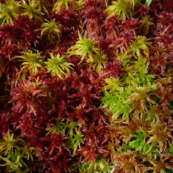
Sphagnum capillifolium in the Welsh uplands
WFE also worked on a potential wind farm development in the mountains of mid-Wales. We undertook a set of habitat and protected species surveys. The site consisted of nearly 15km2 of open mountain side with few existing tracks or roads. With the aid of aerial photos and GPS, our botanists undertook a full survey of the site to create an accurate Phase 1 habitat map and NVC mapping. This will aid the future site planning, identifying key bog habitats which should be avoided by the development.
Over 150 quadrats were sampled and 14 distinct habitat types were identified, ranging from mire to acid grassland, with a variety of distinct bog pool communities. The most common habitat type was Molinia caerulea-Potentilla erecta mire.

